
search
South of France map
South France map detailed. South of France map (Western Europe - Europe) to print. South of France map (Western Europe - Europe) to download. The South of France is one of the most desirable places for a vacation and there are many reasons for that. From the glamour of the Cote d’Azur or the beauty of the mighty Alps, the region is full of natural and cultural attractions as its shown in south of France map. France, not only in its South, has a very complex tourism infrastructure, counting with multiple airports and one of the most dense railway networks in the world. Traveling to any Airport in the South of France is usually a pleasant experience, and the flight availability is high in most airports in the region.
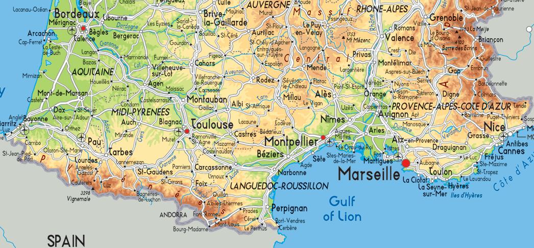
Southern France, also known as the South of France or colloquially in French as le Midi, is a defined geographical area consisting of the regions of France that border the Atlantic Ocean south of the Marais Poitevin, Spain, the Mediterranean Sea, and Italy. The French Riviera ("la Côte d'Azur") is a small part of the south of France, the thin coastal strip from around Cassis (east of Marseille) in the west to the Italian border in the east as its mentioned in south of France map. It is a coastline that gets very crowded in summer, though on account of the rocky coastline, there are still some quiet and peaceful spots to be found.
The Corbières is an area of the South of France. It is picturesque with wine growing areas alternating with garigue and mountainous countryside. The River Aude borders the Corbières to the west and north as you can see in south of France map. To the south is the River Agly and to the east the Mediterranean Sea. The area is known for its wine and Cathare castles. The Minervois is a beautiful area situated between the Canal du Midi to the South, the Montagne Noire to the North, The Narbonne sector to the East and the medieval city of Carcassonne to the West. The Minervois also is particularly renowned for its wine.
The Vaunage is an area of Languedoc Roussillon located between Sommieres and Nimes, north of the Camargue and half an hour from the local beaches. It is a sun-baked valley of “garrigue” (low, soft-leaved scrubland vegetation typical of the Meditarranean region) and vineyards surrounded by hills that isolate it from the surroundings. Its geographical situation has led to a strong regional identity as its shown in south of France map. The Cevennes are a range of mountains in southern France, covering parts of the departements of Ardeche, Gard, Herault and Lozere. This is a quiet rural area so its ideal for relaxing holidays or for fun outdoor adventurous activities. Several parts of the Cevennes are listed by UNESCO: the “Cirque de Navacelles”, the “Causse de Blandas” and the Cevennes National Park.
Saint-Tropez swells in the summer months as yachts creep into port, but a quick stroll through the narrow, cobbled streets of Old Town reveals what attracted celebrities to this former fishing village in the first place. Cannes has been synonymous with cinema for the past 70 years, so slip on your chicest set of heels and take a walk just like the stars along the infamous Boulevard de la Croisette, which separates boutiques like Chanel from the beach as its mentioned in south of France map. Tucked on the coast between Nice and Cannes, Antibes got its start as a Greek colony in the 5th century BC. In the mid-1800s, the town transformed into the haute holiday destination it is today. Admire remnants of its stronghold past by walking along the remaining rampart walls and into the castle housing one of the Old Town’s main attractions: the Picasso Museum.